
FAQs
The Narrow Water Bridge is a landmark cross-border infrastructure project designed to enhance connectivity, support tourism, and promote sustainable transport between County Louth and County Down. Below you’ll find answers to commonly asked questions about the bridge’s design, operation, access, and environmental considerations.
General Project Information
-
What will the bridge be called?
It is currently envisaged that the bridge will be named Narrow Water Bridge.
-
What type of bridge is it?
The Narrow Water Bridge is a cross-border movable bridge. It approx. 195m, two-span, cable-stayed bridge with a rolling bascule mechanism (i.e. opening span).
-
What is the purpose of the Narrow Water Bridge project?
The bridge aims to improve cross-border connectivity, promote tourism, and support local economic development in the region, whilst still allowing marine traffic to navigate the channel.
-
Who is funding the project?
The project is funded by the Shared Island Fund and is a long-standing commitment of the Irish government, reflected in the Programme for Government and New Decade, New Approach.
-
When is the bridge expected to be completed and open to the public?
The current timeline estimates completion by late 2027, subject to construction progress and weather conditions.
-
Who is responsible for maintaining the bridge once completed?
Louth County Council will be responsible for the maintenance of the bridge.
Bridge Access & Usage
-
Will there be a toll on the bridge?
No toll is currently envisaged on the bridge or its access roads.
-
Are coaches and HGVs allowed on the bridge?
The bridge is designed to accommodate heavy goods vehicles and tourism coaches. However, road widths are designed to discourage persistent HGV use.
-
What is the weight restriction on the bridge?
There will be restrictions for abnormal loads in terms of weight and width. Advance signage will be installed upon project completion.
-
What will the speed limit be?
The road currently will be classified as a local road, with a speed limit of 60 km/h in Ireland, aligning with existing limits in Northern Ireland.
Pedestrian & Cyclist Facilities
-
Can the bridge be accessed from the Greenway?
Yes, an access ramp from the bridge access road will connect to the newly completed Greenway.
-
Will there be footpaths and cycle lanes on the bridge?
The scheme includes a combination of shared surfaces, segregated cycle lanes, and footpaths.
-
Will there be protective barriers for pedestrians and cyclists?
The bridge will feature a parapet on one side and a vehicle restraint barrier to separate vehicles from pedestrians and cyclists.
-
Is the bridge accessible to people with disabilities?
The footpath along the bridge will connect with the existing footpath on the A2 in Warrenpoint and will connect via a ramp to the Omeath to Newry Greenway in County Louth.
-
Will public transport be able to use the bridge?
The bridge will be accessible to all forms of transportation.
-
Will there be lighting on the bridge, and will it cause light pollution?
Low-level lighting will be integrated into the bridge’s handrails. Standard public lighting will be installed around the roundabout on the Omeath–Newry Road and existing lights repositioned at the existing A2 and A2 roundabout.
Bridge Operation & Traffic Management
(Vehicular, Pedestrian, and Marine Traffic)
-
How long will it take to open and close the bridge?
The full cycle, including stopping and releasing traffic, will typically take around 10 minutes, depending on the number of marine vessels passing through the channel.
-
How will the bridge opening schedule be communicated to the public?
On the Warrenpoint side, there will be a left-turn stacking lane for vehicles leaving Warrenpoint.
Vehicles arriving from Newry or Mound Road will stack within the designated arrangement at the bridge.
Advanced warning signs (variable message signs) will alert drivers to the bridge’s closure.
On the southern embankment, vehicles will stack on the access road before entering the bridge.
-
What security features will prevent traffic from entering during bridge operation?
Traffic control systems, including wig-wag barriers, will prevent vehicles and pedestrians from accessing the bridge during opening and closing procedures.
-
Will there be a traffic light system?
A traffic management system will be in place for bridge operations, including traffic signals and wig-wag barriers.
-
Will the bridge affect marine traffic or recreational boating?
Marine traffic will be impacted by the bridge. The bridge in its opened position will provide for an unobstructed 20m channel through the bridge, as outlined below.
All Marine traffic must navigate through this 20m channel, which will be delineated by the protection fender system.
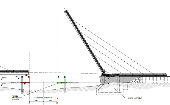
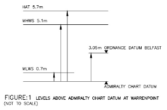
In the closed position the headway below the bridge is 2.98m above the Highest Astronomical Tide being 5.7m, see below.
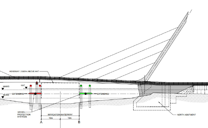
The Narrow Water Bridge Order (Northern Ireland) 2022, sets out the requirements for marine traffic.
-
Will there be lighting on the bridge, and will it cause light pollution?
Low-level lighting will be integrated into the bridge’s handrails. Standard public lighting will be installed around the roundabout on the Omeath–Newry Road and repositioned at the existing A2 and A2 roundabout.
-
Will the bridge lighting affect the local bat population?
Measures have been taken to minimise light pollution, particularly in relation to the local bat population. Low-level lighting is integrated into the bridge’s handrails to reduce upward light spill, and the lighting design has been informed by ecological assessments to avoid disrupting bat flight paths and habitats.
The Big Bridge Project
BAM connects communities to inspire engineering careers and celebrate Narrow Water Bridge.
Read More